

A Smarter Approach to Marine Tracking, Geofencing, and Safety
A Smarter Approach to Marine Tracking, Geofencing, and Safety
Marine operations can change rapidly, even when conditions initially appear favorable. Clear skies and calm waters may soon be replaced by poor visibility, shifting winds, rough seas, or unexpected weather. When operational information is divided between different systems, teams can lose valuable time and face greater operational exposure. ToolKitX provides a cloud native marine surveillance and live tracking platform that brings critical operational information together in one environment. Built for ports, offshore wind projects, marine contractors, energy organizations, and coastal authorities, it gives teams a shared operational map for monitoring active assets and receiving intelligent alerts that help support faster, better informed decisions.
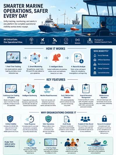
ToolKitX serves as a centralized command environment for maritime operations, offering a comprehensive operational picture comparable to air traffic control, but designed specifically for marine activities. It combines live location and sensor information from AIS, ADS B, GPS, radar, and other connected technologies and presents that information through detailed nautical charts. Intelligent filtering allows operators to focus on meaningful events rather than being overwhelmed by unnecessary data. Teams can monitor vessels nearing restricted areas, recognize potentially unsafe vessel proximity, identify weather related concerns, and detect route deviations while ensuring that all relevant stakeholders are working from the same operational view.
Real time vessel monitoring is available through an interactive map that continuously displays movement, speed, heading, and operational status. Teams can access the platform from offshore locations as well as onshore control centers, maintaining visibility across different operating environments. Supervisors can create specific geofenced areas around ports, offshore wind farms, construction locations, environmentally sensitive zones, exclusion areas, and navigation routes. If a vessel exceeds a defined speed, enters or leaves a designated boundary, or fails to meet an expected arrival time, ToolKitX can send targeted notifications through desktop interfaces, mobile devices, email, and webhook integrations. Role based notifications ensure alerts reach the personnel responsible for taking action without creating unnecessary interruptions. Vessel routes, speed information, and geofence activity can also be retained and exported for compliance records, insurance assessments, incident investigations, and regulatory reporting.
Key Features
Continuous Live Tracking with Historical Playback
Marine teams can view all vessels operating within a selected area or concentrate on an individual asset when necessary. Historical playback provides route and speed visualization for up to 90 days, giving organizations the ability to review incidents, confirm completed activities, examine near misses, and supply supporting records for compliance related work.
Intelligent Geofencing with Flexible Rules
ToolKitX allows teams to create detailed monitoring zones using configurable criteria, including geographic boundaries, vessel speed limits, expected arrival times, and Closest Point of Approach (CPA) calculations. Relevant operations teams, contractors, HSE personnel, and port authorities can receive automated alerts, helping them react sooner while limiting notifications that do not require attention.
Weather Based Operational Awareness
Environmental factors such as wind speed, sea conditions, and temperature can be monitored against established operational thresholds. Advisory, caution, and stop work limits can be configured to help teams determine whether activities such as marine transfers, lifting work, helicopter operations, or offshore activities should continue, pause, or be temporarily stopped.
Early Collision Risk Identification
ToolKitX continuously evaluates vessel movements through its Closest Point of Approach (CPA) monitoring capability to identify possible collision risks before situations become more serious. Detected events are automatically recorded, creating useful information for incident investigations, workforce training, and ongoing operational improvement.
Centralized Asset and Personnel Management
Vessel, helicopter, support craft, and personnel information can be maintained within one centralized repository. Required certifications, including STCW, HUET, GWO, and other mandatory qualifications, can be tracked automatically. Reminder notifications help organizations keep certifications current and maintain operational readiness.
Mobile Access for Field Teams
ToolKitX provides native iOS and Android applications with the core capabilities available through the web platform. Where connectivity is limited, previously synchronized vessel information remains available, enabling supervisors working remotely to review alerts, manage geofences, and access important operational information.
Why Organizations Choose ToolKitX
Organizations use ToolKitX to bring fragmented monitoring activities together within a unified operational environment. By combining AIS, ADS B, GPS, radar, and other positioning technologies, operations, logistics, and HSE teams can maintain a consistent understanding of active marine situations. Immediate alerts for restricted area violations, excessive vessel speeds, and CPA events allow teams to act sooner, helping reduce collision risks, safeguard environmentally sensitive areas, and limit operational disruptions.
ToolKitX also supports audit readiness by preserving operational records and maintaining exportable histories of events. This makes internal assessments, compliance checks, and regulatory reporting more straightforward. From smaller fleets of crew transfer vessels to complex marine operations involving patrol boats, pilot vessels, offshore support craft, and service fleets, the platform can scale with operational requirements while providing role based access for different stakeholders.
Security and compliance are incorporated across the platform. Vessel movements, alerts, and user activities are recorded securely through an immutable audit trail. Data is protected through encryption during transmission and storage while the platform follows recognized security practices without sacrificing operational performance.
Before implementation begins, organizations can digitally configure ports, offshore routes, shipping corridors, wind farms, and harbor layouts within ToolKitX. Geofencing approaches and alert rules can then be evaluated against real operational workflows. This gives teams an opportunity to refine procedures before full deployment, supporting a smoother and more confident rollout.
Book a free demo @ https://toolkitx.com/campaign/gps-tracking/
Browse More

 English
 Arabic
 French
 Spanish
 Portuguese
 Deutsch
 Turkish
 Dutch
Dutch
 Italiano
 Romaian
 Portuguese (Brazil)
 Greek
Greek