


The Importance of Traffic Surveys in Building Smarter Cities in UAE
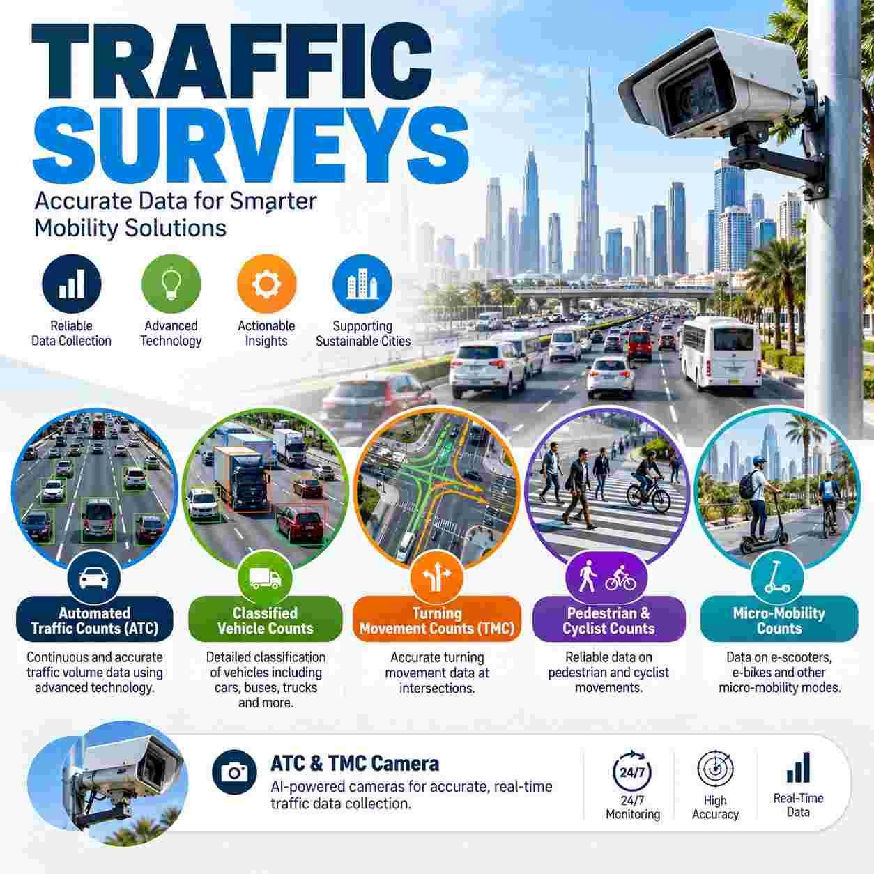
Traffic Surveys are the data foundation of every smart city, because signal timing, public transport, digital twins, and safety programmes can only be as good as the measurements behind them, and this guide shows how each survey type feeds the intelligent mobility plans now shaping the Emirates.
Smart Cities Run on Measured Reality
The Emirates are investing in connected roads, smart signals, mobility apps, and digital models of whole districts. Each of these tools needs trusted inputs: how many vehicles use each road, which turns they make, how many people walk, and how travel habits change through the day and the year.
National and local ambitions such as Dubai 2040, Plan Abu Dhabi 2030, and the UAE Net Zero 2050 strategy depend on this evidence, and agencies such as the Roads and Transport Authority and the Integrated Transport Centre expect it in project reviews.
Layer One: The Network Baseline
Automated Traffic Counts (ATC) record every vehicle on a road for days or weeks, giving the daily, weekly, and seasonal rhythm of each link. Smart signal systems and digital models are calibrated against this baseline, and sensor feeds are checked against it for drift.
Classified Vehicle Counts add the mix of cars, vans, buses, and trucks, which matters for bus priority, freight routes, pavement life, and emission estimates that support sustainability targets.
Layer Two: Junction Intelligence
Turning Movement Counts (TMC) show how vehicles divide between left, straight, and right at each approach. Adaptive signals, junction upgrades, and simulation models all start from these numbers, and small errors here can lead to long queues later.
Junction accuracy pays back quickly in smoother flow and lower fuel use. Learn how smart city traffic data services in the UAE support signal and junction decisions.
Layer Three: People First Streets
Pedestrian & Cyclist Counts reveal how many people walk and ride, where they cross, and when they gather. Walkable districts, shaded routes, safe crossings, and links to metro and tram stops all depend on this evidence.
Micro-Mobility Counts record scooters and shared bikes separately, so cities can set lanes, parking bays, and operating zones using data instead of complaints.
Safety as a Smart City Goal
Counts of people and small vehicles at crossings help identify risky locations before incidents occur, and support programmes that aim to reduce serious injuries.
Cameras and Sensors Working Together
An ATC & TMC Camera records video that software and trained reviewers convert into counts by class and movement. The recording can be checked later, which builds trust in the numbers and supports several studies from one deployment.
Privacy must be part of the design. Footage should be used only for the stated purpose, stored securely, and processed to protect faces and number plates under the federal Personal Data Protection Law. See how a camera-based mobility data team handles this responsibly.
From Counts to Digital Twins
Digital models of a district combine survey data with live sensor feeds, so planners can test a new road, a bus lane, or an event plan before building anything. Surveys act as the ground truth that keeps the model honest, and repeated surveys show whether predictions matched reality.
Data Quality Rules
Calibrated equipment, validation checks, clear records of weather and events, and neutral survey weeks make data safe to reuse. Counts taken during school holidays, Ramadan, or roadworks need clear labels so models do not learn the wrong pattern.
Methods Reviewers Trust
Reliable Traffic Surveys UAE teams follow documented methods and report formats from the Institute of Transportation Engineers and the Highway Capacity Manual, so consultants and authorities can use results directly. Open, well labelled data files make integration with city platforms simple.
Dubai: A Living Laboratory
Traffic Surveys Dubai programmes support a city that tests autonomous vehicles, smart signals, and new transit lines, with review by the Roads and Transport Authority and Dubai Municipality. Corridors such as Sheikh Zayed Road, Business Bay, Dubai Creek Harbour, and Dubai South each need site specific evidence.
Abu Dhabi: Planned and Connected
Traffic Surveys Abu Dhabi work aligns with the Department of Municipalities and Transport and the Integrated Transport Centre, covering island districts such as Saadiyat and Yas, industrial areas like ICAD and KEZAD, and growth along the highways. Heat and long distances shape equipment choices.
Al Ain and the Western Region add variety with long rural corridors and different traffic mixes.
Proof Points That Build Trust
When choosing a survey partner, look for experienced engineers, documented city projects, calibrated equipment, clear quality checks, safe working practice near live traffic, and honest advice about limits. References from consultants and authorities are the strongest evidence of all.
A Simple Starting Point
Begin with a baseline of the busiest corridors and junctions, add pedestrian and small vehicle counts at key crossings, and repeat each year so trends become visible.
Conclusion
Dependable Traffic Surveys power every smart city plan, starting with Automated Traffic Counts (ATC), Classified Vehicle Counts, and Turning Movement Counts (TMC). Pedestrian & Cyclist Counts and Micro-Mobility Counts keep streets safe and people centred, while an ATC & TMC Camera keeps a permanent record. Strong Traffic Surveys UAE practice meets authority expectations at every stage. Traffic Surveys Dubai and Traffic Surveys Abu Dhabi projects each need locally informed planning. Contact Top Precision today to plan your smart city survey.
FAQs
1. How do Automated Traffic Counts (ATC) support smart signals?
They provide the baseline volumes against which signal timing and sensor feeds are calibrated and checked.
2. Why do cities need Classified Vehicle Counts for sustainability plans?
Vehicle mix drives emission estimates, bus priority, freight routing, and pavement life.
3. What do Turning Movement Counts (TMC) add to a junction model?
They show how each approach divides into left, straight, and right movements, which models need to predict queues.
4. Why add Pedestrian & Cyclist Counts to a smart city study?
They show where people walk, ride, and cross, which guides safe crossings, shade, and links to transit.
5. Where do Micro-Mobility Counts help most?
They help place scooter lanes, parking bays, and operating zones using real usage instead of guesses.

 English
 Arabic
 French
 Spanish
 Portuguese
 Deutsch
 Turkish
 Dutch
 Italiano
 Russian
 Romaian
 Portuguese (Brazil)