


How Traffic Surveys in UAE Improve Road Safety and Traffic Management
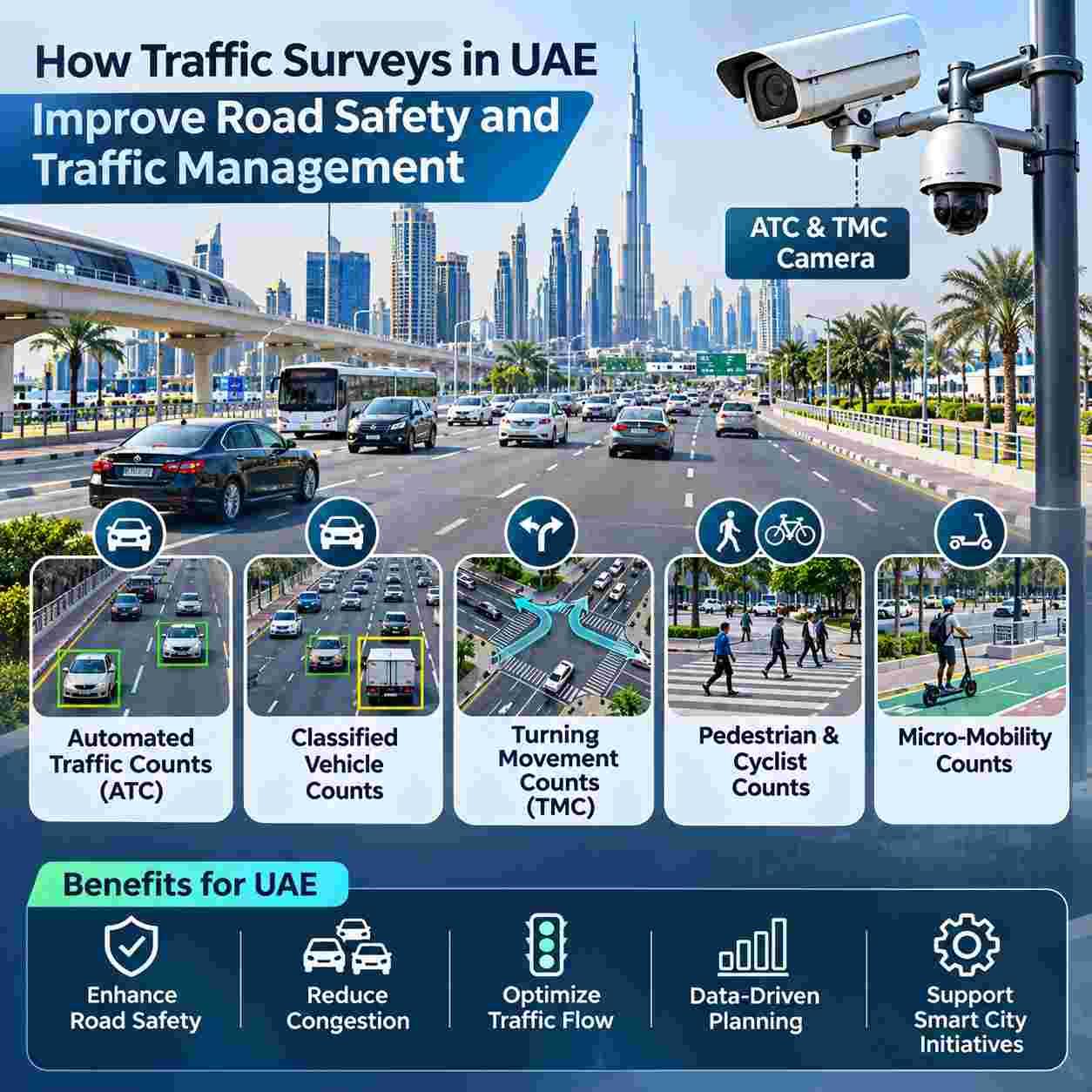
Reliable Traffic Surveys give UAE planners, developers, and road authorities the evidence they need to reduce crashes, ease congestion, and design safer streets. This guide explains the main survey methods, where they add value, and how Top Precisions supports data driven decisions across the Emirates.
The UAE is expanding quickly. New communities, business districts, airports, and mega events place constant pressure on roads, junctions, and walkways. Decisions based on assumptions can lead to wasted investment, unsafe crossings, and chronic delays. Decisions based on accurate field data lead to better signal timing, smarter junction layouts, and infrastructure that matches how people actually travel.
As a specialist data collection provider, Top Precisions focuses on precise and well documented counts that engineers can trust. The sections below describe the survey types, the technology behind them, the regulatory context, and the questions to ask before you appoint a provider.
Why Traffic Data Matters for Road Safety and Mobility
Every safety improvement starts with understanding exposure. Crash numbers alone do not show whether a junction is dangerous because of high volumes, heavy vehicles, poor visibility, or conflicts between drivers and pedestrians. Counts of vehicles, movements, and vulnerable road users reveal the context behind incidents, so authorities can target the right intervention instead of applying generic fixes.
Traffic data also supports daily management. Peak hour patterns, directional splits, and vehicle mix help operators adjust signal plans, plan lane allocations, and schedule maintenance when disruption is lowest. For developers, the same information feeds traffic impact assessments, parking studies, and access design, which are commonly required during approvals in Dubai and Abu Dhabi.
Core Survey Methods Used in Modern Traffic Studies
Different questions need different datasets. Choosing the right method avoids unnecessary cost and ensures the results answer the real problem.
Automated Traffic Counts (ATC) for Continuous Volume and Speed Data
Automated Traffic Counts (ATC) record vehicles over days or weeks using roadside sensors, tubes, radar, or video analytics. They show hourly, daily, and weekly patterns, including peak periods, weekend behaviour, and seasonal variation. Because the data is continuous, it supports capacity analysis, speed compliance reviews, and long-term monitoring of corridors such as arterial roads, access roads, and industrial areas.
Classified Vehicle Counts for Understanding Fleet Mix
Classified Vehicle Counts separate traffic into categories such as cars, buses, light trucks, heavy goods vehicles, and motorcycles. This matter because a heavy vehicle has a very different effect on pavement wear, junction capacity, and safety than a passenger car. Logistics zones, ports, construction corridors, and school areas all benefit from knowing exactly what types of vehicles use the road and at what times.
Turning Movement Counts (TMC) for Junction Design and Signal Timing
Turning Movement Counts (TMC) capture how many vehicles turn left, go straight, or turn right from every approach of an intersection, usually in short intervals during peak periods. These counts are the foundation of junction capacity models, signal optimization, and layout redesign. They show which movements cause queues and which conflicts create risk, so engineers can adjust phasing, add turn lanes, or reshape the junction with confidence.
Pedestrian & Cyclist Counts for Safer Walking and Cycling
Pedestrian & Cyclist Counts measure how many people walk or ride through crossings, promenades, bus stops, and shared paths. They highlight desire lines, crossing behaviour, and peak demand near schools, malls, metro stations, and residential areas. This evidence helps authorities justify new crossings, wider footpaths, shade, lighting, and protected cycle tracks in line with walkability goals such as those set out in the Dubai 2040 Urban Master Plan.
Micro Mobility Counts for E Scooters and Shared Bikes
Micro Mobility Counts record the use of e scooters, shared bicycles, and similar devices. As these modes grow in popular districts, operators and regulators need to know where trips start, which routes are busy, and where conflicts with pedestrians or vehicles occur. The data supports decisions on parking zones, speed limits, dedicated lanes, and enforcement priorities.
Technology Behind Accurate Field Data
Modern surveys combine careful fieldwork with intelligent software. High definition video, radar sensors, and analytics reduce human error and allow results to be verified later. An ATC & TMC Camera records the scene from a safe position, and trained analysts or validated algorithms extract counts by direction, class, and time interval. Because footage can be reviewed, questions about any figure can be answered with evidence, which improves transparency and trust.
Good practice also includes site reconnaissance, clear survey plans, weather and event notes, calibration checks, and quality control on every dataset. Results are delivered in structured formats that can be loaded directly into modeling tools, so engineers spend their time on analysis rather than cleaning data.
Traffic Surveys UAE: Where Data Delivers the Most Value
Across the country, survey data supports a wide range of projects, and each benefit from tailored planning.
Government Road Safety and Network Management
Authorities use counts to identify high risk locations, evaluate safety measures, and prioritize investment. Before and after studies show whether a new crossing, lane change, or speed management scheme actually improved conditions.
Urban Development and Traffic Impact Assessments
Master developers and consultants rely on baseline counts to forecast the effect of new communities, towers, schools, and retail centers. Accurate baselines protect both the developer and the authority by ensuring that required road improvements match real demand.
Parking, Logistics, and Event Planning
Entry and exit counts, vehicle classification, and peak profiling support parking design, truck routing, and temporary traffic plans for exhibitions, festivals, and sporting events.
Schools, Hospitals, and Public Spaces
Pedestrian and vehicle data around schools, hospitals, and public squares reveals pick up congestion, unsafe crossings, and opportunities for calmer streets and safer drop off arrangements.
Regional Focus: Dubai and Abu Dhabi
Dubai combines dense commercial districts, rapid growth, tourism, and a strong push toward walkable and multimodal neighbourhoods. Traffic Surveys Dubai projects often involve the Roads and Transport Authority, private developers, and consultants who need fast, high quality data for junction studies, mobility plans, and impact assessments in busy corridors.
Abu Dhabi has its own planning framework, with the Integrated Transport Centre and the Department of Municipalities and Transport guiding mobility policy across the emirate. Traffic Surveys Abu Dhabi work frequently supports island developments, government campuses, industrial zones, and long corridors where accurate volumes and vehicle classes drive design decisions. A provider familiar with permit processes, site safety expectations, and reporting standards in both emirates reduces delays and rework.
Conclusion
Accurate Traffic Surveys give planners and authorities the evidence needed to improve road safety and traffic flow, and Traffic Surveys UAE projects benefit most when methods are rigorous. Automated Traffic Counts (ATC), Classified Vehicle Counts, and Turning Movement Counts (TMC) reveal volumes, fleet mix, and junction conflicts that guide smarter design. Pedestrian & Cyclist Counts and Micro Mobility Counts ensure that safer streets also serve people who walk, ride, and scoot. A modern ATC & TMC Camera keeps data verifiable, whether you need Traffic Surveys Dubai or Traffic Surveys Abu Dhabi support.
FAQs
1. What does an ATC & TMC Camera record during a survey?
It records continuous video of the road or junction from a safe position. Analysts or validated software then extract vehicle volumes, classes, turning movements, and time intervals, and the footage remains available for checking any figure later.
2. Why are Classified Vehicle Counts important?
Different vehicles affect safety, capacity, and pavement life in different ways. Knowing the share of buses, trucks, and cars helps engineers size lanes, set signal timings, plan loading areas, and protect vulnerable users near heavy traffic.
3. When are Pedestrian & Cyclist Counts]and Micro Mobility Counts needed?
They are valuable whenever a project affects walking, cycling, or shared device use, such as new crossings, school zones, mall frontages, station areas, or promenades. The results show demand, peak times, and conflict points so designs can be justified with evidence.
4. How do Traffic Surveys Dubai projects differ from Traffic Surveys Abu Dhabi projects?
The engineering methods are similar, but approvals, authority requirements, site access rules, and reporting expectations can differ between the two emirates. A provider with experience in both can plan permits and field work efficiently and present results in the format each authority expects.
5. How do Automated Traffic Counts (ATC) differ from Turning Movement Counts (TMC)?
Automated counts measure total volumes on a road section over a long period, showing daily and weekly patterns. Turning movement counts focus on a single junction and record every turn from every approach, usually during peak periods. Most studies use both to get a full picture.

 English
 Arabic
 French
 Spanish
 Portuguese
 Deutsch
 Turkish
 Dutch
 Italiano
 Russian
 Romaian
 Greek